In the field of land measurements – people's concern for more than two millennia to measure and study the shape and dimensions of our planet – new problems are constantly emerging, problems whose solution must be given by current and future surveying engineers. Fortunately, the desire and Human need for information is continually accompanied by new discoveries also in the field of land measurements, the advantage of technology and computerization opening wide perspectives for a better understanding of the environment.
Land measurements and Cadastre study programme from the Politehnica University of Timişoara, Civil Engineering Faculty was established in 1991 being registered in the Official documents from 2002 as accredited specialization. This study programme is part of the geodetic engineering field, a distinct profile in the Romanian specialties nomenclature.
The development of geodetic profile education has been imposed both at national and local levels, for economic and scientific needs, taking into account that the number of specialists in the field of land measurements is still below the requirements of this activity domain.
The structural changes in our country after 1989, through the transition to market economy and the development of private property, have produced fundamental changes in the field of cadastre, both in terms of immovable property evidence and cadastral plans.
Updating and modernising the cadastre to make it multifunctional, requires a large number of specialists with a possible uniform distribution at national level.
The curricula is adapted to the open educational system, the analytical programs being correlated with similar programs in the country and abroad for recognition based on the transferable credit system. Our students participate to different ERASMUS programmes abroad such as: Norway, Italy, Germany, Croatia, courses recognized under this transferable credit system.
The fulfilment of the objectives that stand before the surveyor engineer requires its thorough preparation in the field of land measurements, ensured both by fundamental disciplines (mathematics, physics, computing technique etc.), as well as by technical disciplines (topography, geodesy, cartography, photogrammetry, cadastre etc.).
In the same time, for the complete training of the students, disciplines from the beneficiary domains of their activity, namely, civil engineering, urbanism, transportation, management, etc. have a substantially contribution.
Starting with the academic year 2005/2006, a new 4-year structured education plan was introduced for the technical field (bachelor) with 2 years of Master studies (diplomat engineer) – in the frame of Bologna program.
Educational Offer:
Bachelor Studies – 8 semesters –Land Measurements and Cadastre study programme
Master's Degree – 4 semesters – Cadastre and Immovable Evaluation master programme
PhD Studies – 6 Semesters - doctoral field: Geodetic engineering
Habilitated professors:
Prof. Carmen GRECEA, PhD
Prof. Sorin HERBAN, PhD
It can be stated that the Land Measurements and Cadastre study programme had an upward evolution justifying its full existence. The mission of training geodetic specialists is outlined both at the level of students and teachers. The quantitative and qualitative level of students follows an ascending route, from admission to graduation, which reflects their interest and the care of teachers to satisfy the education process. This can also be seen on the official Facebook page where the current students and former graduates with whom the teachers keep a close connection are found. https://www.facebook.com/geodezie.timisoara.UPT/
The study programme consolidation strategy focuses on the following objectives:
- continuous improvement of the curricula and educational programmes, in accordance with the evolution of the specialty technique in the field of geodesy, with the labor market and constantly reporting to similar institutions in the country and European Union;
- professional improvement through PhD studies and specialization courses;
- development of topical research areas such as: cadastral work automatization, land information systems, GIS, satellite technologies, geo-spatial modelling, remote sensing and digital photogrammetry, 3D modelling, BIM.
The educational curricula of the Master Studies program managed by the Land Measurements and Cadastre study programme, entitled Cadastre and Immovable Evaluation is well defined and correlated with other educational curricula from similar specializations.
Functioning since 1991 as a well-individualised study programme, over 600 graduates have successfully covered the entire design and execution of works in this domain, especially for the country's western area.
Graduates - surveying engineers, are employed in public institutions (cadastre and real estate advertising offices, local councils, design institutes, autonomous institutions etc.) and private companies with cadastre related activities (construction, urbanism, local administration) or they work on their own as licensed persons.
The university, respectively the faculty provides the necessary material basis for quality education, educational spaces, appropriate laboratories, well-equipped library and a sufficient number of teachers with appropriate academic training.
The Land Measurements and Cadastre study programme was conceived as an interdisciplinary specialization, which prepares specialists able to give effective solutions for the design, execution and exploitation of works in the field of land measurements, with different destinations (engineering topographic works and cadastre, systematization, architecture etc.). This area is of perspective both in Romania and in Europe, with requirements for the labour market.
All teachers have approached and addressed in their scientific activity numerous themes in the field of geodetic engineering, embodied through publications in specialized journals, manual editing, courses, laboratory works, participation at internal and international symposiums in the field, developing research grants and contracts. The teachers are part of the professional associations in the field, the Romanian General Association of Engineers (AGIR), the Surveyors Union of Romania (UGR), the Surveyors Association in Timis County, the Romanian Surveyors Order (UGR), the Romanian Society of Geotechnics and Foundations, the International Geotechnical Society, the Road Society, the Balkan Environmental Association (BENA) etc.
Main research areas:
Politehnica University of Timişoara has developed long-term, short-term and medium-term strategies containing objectives, projects and expected results, as well as the means to achieve them.
Below are some of the research directions addressed by the academic staff of the Land Measurements and Cadastre study programme:
- Constructions monitoring issues;
- Geospatial modelling for terrestrial measurements;
- Use of Geographic Information Systems (GIS) for urban development;
- Database design, development and management for public administration;
- Special applications of photogrammetric exploitation;
- Surveying engineering and Cadastre;
- Improving methods for tracking the movement of surfaces located in mining areas/areas with landslides/seismic zones.
Also research for:
- Creation, analysis and management of geodetic and cadastral data;
- Development of the Romanian Geodetic Control Network using permanent GPS stations;
- Monitoring and automation of terrestrial measurements;
- Technical solutions to ensure the stability of industrial objectives with different destinations;
- Geodetic assessment of crustal movements in the Banat area;
- GIS development using Intergraph technology;
- Remote Sensing and digital photogrammetry;
- Monitoring constructions behaviour;
- Landslide monitoring;
- Creating the database for urban administration management;
- 3D modelling of the urban environment;
- Transition to Smart City concept.
DOMAIN DESCRIPTION:
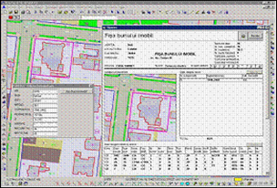
The geodetic and cadastral support has a wide contribution both for scientific purposes and for the economic development of a territory, especially in civil engineering, real estate transactions and agrarian reforms. In addition, the digital cadastral map represents an important tool for planning and management. It contains data related to property, terrain and also natural resources.
The modern cadastre has as primary concern the detailing of the land parcel information on an individual level. It must serve the needs of the community and of the individual.
The benefits relate to: goods and transportation management, credit security, demographic analysis, development control, emergency planning and management, environmental impact assessment, real estate transactions and land market analysis, property taxation, agrarian reform, owners and property records, statistical data monitoring, property management, location, management and protection of archaeological sites etc.
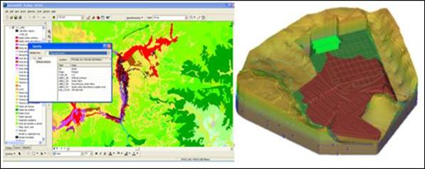
To be easily accessible, the solutions are provided by Geographic information Systems (GIS), which integrate data on land use and urban networks, providing the necessary tools for spatial analysis and modelling.
In order to obtain high precision geodetic measurements, the GNSS reference stations network has been carried out on the territory of Romania.
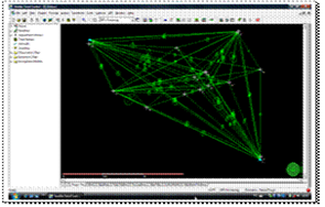
With the aid of Satellite Geodesy we can locate areas with high geophysics activity by mapping crustal deformations, seismicity and other factors. The integration of this spatial data into a Geographic Information System (GIS) places constraints related to identifying the distribution of geodynamic settings, geometry and type of active crustal defects, to establish spatial relations between crustal structures and natural disasters, all being related to environmental protection requirements.
In Timișoara area measurements, evaluations and analyses are performed using points in the GNSS reference stations network. They are used for the development of cadastral applications, topographic engineering projects, urban evaluation and land management monitoring.
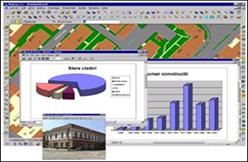
Today, the cadastral GIS provides functionality for each phase of data processing, including the creation of the digital map, printing topographical and cadastral plans, generating and combining geo-referenced data to obtain an effective database.
The research results are disseminated as follows: publications for academic or scientific purposes, PhD theses and research contracts through the laboratory authorized by the National Agency for Cadastre and Land Registration.
Scientific and technical engineering research activity
- Topographic technologies using Global Positioning System for control cadastral networks – PhD Thesis;
- Special applications of photogrammetric exploitation – PhD Thesis;
- Contribution to applying topographic methods for studying and monitoring terrain and constructions - PhD Thesis;
- Contributions to the determination of building subsidence and deformations using modern topographic techniques – PhD Thesis;
- Improving the monitoring methods of the surface movements, situated in the mining zones – PhD Thesis;
- Contributions regarding the geodetic evaluation of displacements and deformations of buildings – PhD Thesis;
- Using modern methods in Surveying for special constructions behaviour monitoring- PhD Thesis;
- Monitoring, modelling and analysis of landslides and reinforced earth constructions using modern geodetic technologies – PhD Thesis;
- Contract no. 90 / CP / I / 14.09.2009 - Development of the laboratory for large scale testing, Beneficiary: ANCS;
- Contract no. 18 / 26.01.2009 - Cadastral and execution studies for PUZ, Timis County;
- Topographic engineering measurements for S.C. Holcim (Romania) S.A., Beneficiary: S.C. Holcim (Romania) S.A. Bucharest, Arad agency;
- Contract no. 182/2008 2010 Elaboration of data basis for the use of the geospatial information with a view to the administration of the cemeteries from Timişoara – data acquisition and updating. Beneficiary: Town Hall of Timişoara;
- Contract no.174 /30.12.2010 – Studies and experimental research concerning the improvement of technological performances of Francis FVM DE 57.5-128.5 turbines, hydro-electrical plant Bradisor, Romania;
- POSDRU ID 63140 – Online university cooperation network for providing higher competences in geodesy;
- Contract no.135/2011- Studies and topographic surveys needed for the expertise of the pump foundations from CET Centre and CET South, Timişoara;
- Development of Urban Green Space Monitoring Technique with Remote Sensing and its Application – 2016, PN III 2016;
- Contract SEE 2009-2014, Protecting biodiversity and the importance of ecosystem services (ECO-INTERAGE).
STUDY PROGRAMME LABORATORIES:
- Land Measurements and Cadastre Laboratory, licensed by National Agency for Cadastre and Land Registration (no. 973/15.12.2009 B license)
This laboratory is equipped both with traditional and modern technologies:
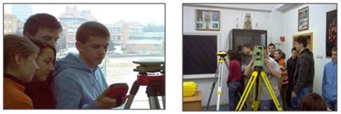
Dahlta 010 Tachymetry, 010A Theo Theodolite, Theo 020 Theodolite, Wild Theodolite, Ni004 level, Ni007 level and Ni 025 level;
Builder T100 Theodolite, 13C RecElta Total station, Leica TC407 Total station, Leica TC805 Total station, Leica Sprinter 100M digital level, Leica Sprinter 150M digital level, GPS SR20 system - 3 receivers and Leica 1200 system, Zoller Fröhlich laser scanner.
- Automatization of cadastral works and GIS - Registered Research Laboratory – RRL Intergraph Laboratory
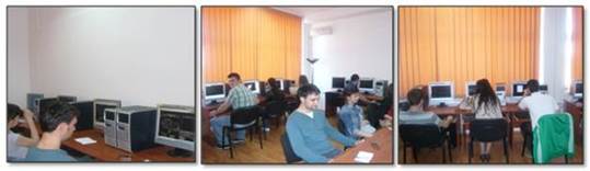
The laboratory is equipped with 12 PC and specialized software such as: Toposys 5.6, Toposys 7.0, Mapsys 7.5, Mapsys 8, AUTOCAD 3D CIVIL and ERDAS Imagine, Intergraph Solutions.
- Geodesy Instruct – Media Laboratory developed as a result of the POSDRU 63140 project
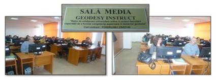
Main facilities of this laboratory are: 25 PC, 9 laptops, 34 licensed software and video projector.
Specialty courses are focused on three main directions:
- Geodesy – Cartography;
- Topography – Cadastre;
- Photogrammetry – GIS.
In the Geodesy-Cartography field a training related to Earth measuring and representation as a whole and on portions is ensured. The main projection systems used in Romania and the modalities of drawing and editing maps are studied.
For the Topography-Cadastre field, future geodetic engineers study modern measuring technologies and techniques necessary for cadastral and topographic maps and plans realization and also for designing, setting out, execution and monitoring the behaviour in time of all kind of constructions.
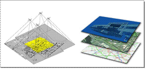
The Photogrammetry-GIS field provides the techniques and methods of drawing maps and topographical plans using aerial photograms and satellite images necessary to develop databases using geo-spatial information.
Thus, the competences and knowledge of the graduates from the Land Measurements and Cadastre study programme can be synthesized as follows:
- Understanding and proper use of Mathematics concepts, Physics, Measurement techniques, Computer Aided Drawing and Informatics;
- Identifying, analysis of conflictual problems and their resolution with favourable economic conditions;
- Communication, team work, interdisciplinary cooperation and innovation;
- Knowing and using geodetic instruments and tools;
- Geodetic networks design, execution and processing;
- Designing and execution for technical works necessary for updating general and specialty cadastre.
ACHIEVEMENTS IN THE FIELD OF RESEARCH AND TECHNICAL-ENGINEERING ACTIVITIES
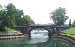
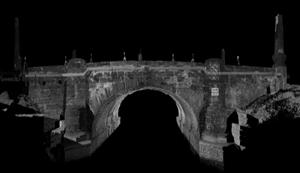
- Deformation monitoring for engineering projects
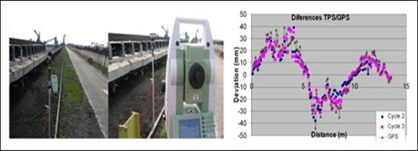
Special construction monitoring / Displacements evaluation by using GPS and total station
- Interdisciplinary collaboration for constructions and architectural works management and systematization
 |
 |
 |
- Thematic maps generated from the database
- Studies and geodetic solutions to monitoring and assessing crustal movements
- Using global navigation satellite system to accuracy improvement of cadastral works
- Updating urban GIS database
- 3D modelling